


You will find popular beaches, wildlife parks, tea estates, and mountain scenery in almost every Sri Lanka travel guide. Those experiences deserve attention. Yet another side of the island often stays hidden behind larger tourism campaigns and popular social media posts. The forts in Sri Lanka preserve centuries of conflict, trade, engineering, and cultural change. These places do not stand as isolated ruins behind fences. They continue to function as living spaces where people work, worship, walk, eat, and build their daily lives around walls that rose several centuries ago.
A walk through these historical sites feels different from a visit to a traditional museum. You hear church bells near old bastions in Galle. You see fishing boats beside colonial walls in Mannar. You pass through streets where Dutch-era buildings stand beside cafés and homes. In Trincomalee, deer move freely through a colonial military zone while waves break against the coast below. These experiences create a stronger connection to the past because history is embedded in daily life rather than displayed behind glass.
Sri Lanka occupied one of the most important positions in the Indian Ocean for many centuries. Traders from India, Arabia, Persia, China, and Southeast Asia visited the island long before European powers arrived. The island attracted attention for its spices, pearls, elephants, gemstones, and cinnamon. European nations recognised the commercial value of controlling ports around the island. Portuguese forces reached Sri Lanka in 1505. Dutch forces later expanded their influence after defeating the Portuguese in many coastal regions. British rule followed in the late eighteenth century.
Each colonial power left physical evidence across the island. Fortifications appeared along major ports and strategic coastal areas. Some locations functioned as military centres. Others served as trading hubs or administrative towns. Several structures changed hands between colonial powers and underwent major reconstruction over time. These places still tell stories about the ambitions of empires and the people who lived within their influence.
This journey through the historical forts in Sri Lanka takes you from the southern coastline to the island’s northern edge. Along the way, you will find UNESCO World Heritage landmarks, lesser-known colonial sites, dramatic ocean views, and locations where archaeology continues to reveal new details about Sri Lanka’s past.

The Famous Lighthouse – Galle Fort (Photo: Diwyanjalee Wanigasekara, CC BY-SA 4.0)
Why Historical Forts in Sri Lanka Matter
Many countries preserve old fortifications, but in Sri Lanka, the picture is different: the sites continue to function as part of modern life. A visitor does not simply arrive, take photographs, and leave. These places often sit within active communities where local culture continues to grow around historical foundations.
Sri Lanka’s location in the Indian Ocean shaped much of its history. Maritime trade routes connected East Asia, the Middle East, India, and Europe. Ships carrying spices, textiles, ceramics, and precious goods moved through these waters. Control over coastal ports brought economic influence and military advantage. Colonial powers understood this reality very well.
Portuguese authorities focused heavily on establishing defensive positions and protecting trade interests. Dutch engineers later expanded and strengthened existing structures, using military design principles common in Europe at the time. British authorities introduced further changes and shifted attention towards administration and commercial development.
These fortifications tell a broader story about migration, religion, architecture, and cultural exchange. Portuguese influence introduced Roman Catholic traditions in several coastal regions. The Dutch administration affected urban planning and legal systems. British influence shaped transportation and public institutions.
The archaeological value of these sites also deserves attention. Sri Lanka’s Department of Archaeology continues preservation work and historical research throughout the country. Conservation projects protect structures from environmental damage and support tourism development. Archaeological studies also reveal information about construction methods, daily life, and military practices during colonial periods.
The result goes beyond old walls and gates. You see layers of history built over one another.

Jaffna Fort (Photo: Rehman Abubakr, CC-BY-SA-4.0)
UNESCO Recognition and Global Importance
Among all colonial heritage sites in Sri Lanka, Galle Fort receives the highest level of international recognition. UNESCO added the Old Town of Galle and its Fortifications to the World Heritage List in 1988 for their historical and architectural significance.
UNESCO identifies Galle as one of the best-preserved examples of a European-built fortified city in South and Southeast Asia. The site combines European planning principles with local traditions, materials, and environmental conditions. Dutch engineers adapted their designs to fit a tropical coastal setting rather than simply copying European structures.
The city itself forms part of the attraction. Visitors do not enter a single building or monument. They enter a complete historical environment where streets, walls, churches, homes, and public spaces work together as a unified urban system.
This UNESCO status also strengthens conservation efforts and increases international attention towards Sri Lanka’s cultural heritage. Many foreign visitors first hear about Galle through UNESCO travel resources and later continue their journey towards other historical locations across the island.
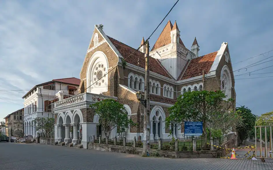
All Saints’ Anglican Church – Galle Fort (Photo: A. Savin)
Who Should Visit the Forts in Sri Lanka?
Historical sites attract a wide range of travellers because each location offers a unique experience.
History enthusiasts often spend hours examining old gates, military structures, and architectural details. Some travellers arrive with a strong interest in colonial history and archaeology. Others enjoy understanding how places evolved.
Photographers often plan their schedules around sunrise and sunset. Light changes quickly along Sri Lanka’s coastline. The stone walls at Galle, the lagoon views of Jaffna, and the cliffs of Trincomalee create strong visual contrasts during early morning and late afternoon hours.
Families also find these sites accessible because many locations offer open spaces and straightforward walking routes. Children often respond well to forts because the experience feels active rather than formal.
Slow travellers frequently stay inside heritage districts for several days. Galle Fort serves as a good example. Visitors spend mornings walking through narrow streets and afternoons sitting in cafés or exploring local shops.
Beach travellers also fit naturally into these routes, as many forts are close to coastal attractions.
The strongest reason to visit these places comes from their variety. No two forts create the same experience.
Galle Fort, Sri Lanka’s Living Heritage City

Old Dutch Hospital – Galle Fort (Photo: Dan Lundberg, CC-BY-SA-2.0)
Location
Galle Fort sits along Sri Lanka’s Southwestern Coast, roughly 125 kilometres from Colombo. The Southern Expressway reduces travel time significantly, and most travellers reach Galle within two or two and a half hours from the capital.
Brief History
Portuguese forces first built fortifications around Galle during the late sixteenth century after recognising the strategic value of the natural harbour. Dutch forces later captured the settlement and transformed much of the structure into the fortified city visible today.
Dutch reconstruction during the seventeenth century changed the scale and organisation of the site. Engineers expanded defensive systems and developed a structured urban layout inside the walls. British authorities later occupied the fort and introduced administrative changes while preserving much of the earlier Dutch character.
Centuries later, many sections still survive in good condition.
Architecture
Galle Fort presents one of the clearest examples of Dutch military and urban planning in Asia. The city follows a grid street system with organised blocks and defensive zones.
Massive ramparts surround the city and face the Indian Ocean. Bastions protect different sections of the perimeter. Builders used coral stone, granite, and limestone materials adapted for local conditions.
Walking through Galle offers a different experience from visiting many archaeological sites because the fort feels complete rather than fragmented. Streets connect naturally with one another. Churches stand beside houses and public buildings. Small details reveal themselves throughout the city.
Special Features and Current Remains
Galle Fort differs from most historical locations because people still live inside its walls. The fort operates as a functioning neighbourhood rather than a preserved shell from the past.
Visitors encounter narrow streets lined with colonial buildings, restored homes, and small businesses. Several structures preserve Dutch architectural features, including verandas, arches, courtyards, and decorative windows.
Key attractions include the Galle Lighthouse, the Clock Tower, the Dutch Reformed Church, the National Maritime Museum, and the Dutch Hospital complex.
The National Maritime Museum presents material connected with Sri Lanka’s maritime history and underwater archaeology. Historical artefacts and exhibits explain the country’s long relationship with the sea.
The fort also gained international attention following the 2004 Indian Ocean tsunami. Thick defensive walls absorbed much of the force and protected large sections within the fort area.
Best Time to Visit
December through April brings dry weather to Sri Lanka’s Southwest Coast. Early morning and late afternoon create comfortable conditions for walking.
Nearby Attractions
Many travellers combine Galle Fort with nearby destinations because the surrounding area offers a strong variety.
Unawatuna Beach sits a short distance away and attracts visitors with calm waters and restaurants. Jungle Beach provides a quieter setting surrounded by vegetation. Whale-watching excursions operate from Mirissa during the season. The Japanese Peace Pagoda overlooks the coastline and offers broad views across the ocean.
A single afternoon inside Galle Fort covers major attractions. However, many visitors extend their stay because the atmosphere changes throughout the day. Morning walks feel quiet and relaxed. Evenings bring a different energy as cafés and restaurants come to life.
Jaffna Fort and the Story of Northern Sri Lanka
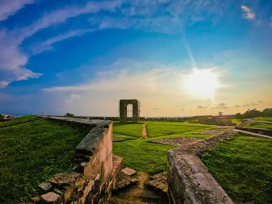
Jaffna Fort (Photo: Eshan Malaviarachchi, via Unsplash)
As you travel north across Sri Lanka, the landscape begins to change. Palmyra trees appear across the horizon. Roads become flatter and drier. Food traditions shift. Language patterns also change. Jaffna introduces visitors to a different side of the country, and Jaffna Fort sits at the centre of that experience.
Location
Jaffna Fort stands beside the Jaffna lagoon in Sri Lanka’s Northern Province.
Brief History
Portuguese authorities built Jaffna Fort in 1618 after securing control over the region. Dutch forces later captured the site and expanded its defences in accordance with European military standards.
The fort experienced major damage during Sri Lanka’s civil conflict. Restoration projects later repaired several areas and improved visitor access.
Architecture
Dutch military engineers designed Jaffna Fort with a pentagonal layout and large defensive bastions. Thick walls surround open interior spaces designed for security and military movement.
The structure creates a stronger sense of scale than many first-time visitors expect.
Special Features and Current Remains
Jaffna Fort feels very different from Galle. Galle feels active and urban. Jaffna feels open and quiet.
Visitors walk across broad grounds surrounded by massive walls and lagoon views. Sections of the fort still show evidence of damage and reconstruction.
The site includes gateways, defensive structures, open spaces, and panoramic views of the surrounding landscape.
Best Time to Visit
June through September usually brings dry weather to Northern Sri Lanka. Early morning and late afternoon create comfortable conditions for exploring the fort walls and enjoying views across the Jaffna Lagoon.
Nearby Attractions
Travellers often pair Jaffna Fort with Nallur Kandaswamy Temple, Delft Island, and Nagadeepa Temple.
The northern region also offers one of Sri Lanka’s strongest food cultures. Seafood dishes, crab curry, and local palmyra products create another layer within the travel experience.
Fort Frederick

The Entrance – Fort Fredrick (Photo: AntanO, CC-BY-SA-4.0)
Location
Fort Frederick stands in Trincomalee on Sri Lanka’s Eastern Coast, where one of the world’s finest natural harbours shaped centuries of maritime history. The location itself explains why so many powers fought for control over this part of the island. Trincomalee sits beside deep waters that offer protection for ships travelling through the Indian Ocean trade routes. Even before entering the fort area, visitors notice a different atmosphere from southern coastal cities. The roads become quieter, dry forests surround the route, and the sea appears between trees and rocky cliffs.
Brief History
Portuguese authorities constructed Fort Frederick in 1624 after taking control of Trincomalee and identifying its military value. Historical records indicate that Portuguese builders used stones from the destroyed Koneswaram Temple during construction. Dutch authorities later captured the region and strengthened its defences in accordance with the military planning methods used throughout their colonial territories. British forces later maintained control because Trincomalee harbour held exceptional strategic value for naval operations.
Throughout these different periods of rule, the fort continued serving the same larger purpose. Geography itself protected and strengthened the location. Political control changed, but the harbour remained valuable.
Architecture
The architecture of Fort Frederick differs from the organised urban layout visible at Galle Fort. Engineers designed the structure to blend with the natural landscape rather than imposing a rigid pattern. Thick stone walls follow the contours of the elevated terrain, while gateways and defensive structures control movement across the site.
Builders understood that the rocky landscape and surrounding cliffs already created natural defences. The fort, therefore, feels connected to its environment rather than imposed upon it.
Special Features and Current Remains
Fort Frederick offers one of the most distinctive experiences among the forts in Sri Lanka, as visitors encounter nature and history together. Deer move freely through the grounds and rest beneath trees beside roads and historical structures. The atmosphere feels peaceful and often surprises first-time visitors.
Surviving gateways, sections of original walls, and defensive structures still preserve the site’s historical identity. The fort also serves as the route towards Koneswaram Temple and Swami Rock, where dramatic cliffs overlook the sea. The views from this location stretch across the coastline and remain among the strongest coastal scenes in Sri Lanka.
Best Time to Visit
The Eastern Coast generally receives favourable weather conditions between May and September. Morning and late afternoon offer comfortable temperatures and better conditions for photography, as light becomes softer and ocean views clearer.
Nearby Attractions
Many visitors continue beyond the fort and combine the experience with nearby attractions. Koneswaram Temple is located in the same area and remains one of Sri Lanka’s important Hindu religious sites. Pigeon Island National Park attracts snorkelling enthusiasts because of its coral reefs and marine life. Nilaveli Beach, Uppuveli Beach, and Marble Beach offer quieter coastal settings, while whale-watching excursions operate during suitable seasons.
Batticaloa Fort

Batticaloa Fort (Photo: Anton Croos, CC-BY-SA-4.0)
Location
Batticaloa Fort stands beside the Batticaloa Lagoon in Sri Lanka’s Eastern Province, where water shapes much of the landscape and local life. The town creates a different impression from larger tourism centres, with an atmosphere that feels slower and more relaxed. Lagoons stretch across the surrounding area, and fishing remains part of everyday life.
Brief History
Portuguese authorities established the original fort in 1628 because controlling the lagoon region held strategic importance. Dutch authorities later captured the site and expanded the structure in accordance with European military planning methods. British administrators later adapted the fort for administrative use.
Batticaloa developed differently from larger colonial centres because regional trade, waterways, and local communities strongly influenced its growth.
Architecture
The fort follows a four-bastion design that reflects Dutch military engineering principles. Strong walls surround the complex, while the lagoon acts as a natural protective feature around parts of the structure.
The architecture reflects practical thinking because environmental conditions are incorporated into the defence system. Water strengthened the site naturally and reduced the need for additional fortifications.
Special Features and Current Remains
Visitors often notice the peaceful environment before focusing on individual structures. Batticaloa Fort rarely attracts large crowds, allowing a slower exploration of the site. Government offices continue to operate in sections of the complex, meaning the location still serves practical purposes in the town.
Original walls, gateways, and colonial structures continue to survive within the grounds. The nearby lagoon adds another dimension because changing light conditions create different reflections and views throughout the day.
Best Time to Visit
The eastern region usually experiences favourable travel conditions between May and September, when rainfall decreases, and outdoor exploration becomes easier.
Nearby Attractions
Travellers often combine Batticaloa Fort with Batticaloa Lagoon, Passikudah Beach, Kalkudah Beach, and nearby fishing communities. Boat rides through lagoon areas also create opportunities to experience the surrounding landscape from a different perspective.
Mannar Fort

Mannar Fort (Photo: David Stanley, CC BY 2.0)
Location
Mannar Fort stands within Mannar town on Sri Lanka’s Northwestern Coast, where the landscape begins to change once again. Long stretches of open land, wetlands, and dry vegetation dominate the region. Visitors travelling towards Mannar often notice that the environment feels distant from busier tourism destinations.
Brief History
Portuguese authorities constructed the original fort during the sixteenth century because Mannar occupied an important position along maritime routes connecting Sri Lanka and southern India. Dutch authorities later captured the area and expanded the defensive systems to meet their military requirements.
Trade and movement between regions shaped Mannar throughout history. Military activity formed one part of the area’s larger significance.
Architecture
The structure follows a square design with bastions positioned at each corner. Military engineers focused on practical defence rather than decorative design. The layout reflects direct planning, with visibility and security as the primary goals.
Architecture within Mannar Fort, therefore, feels simpler than the urban design of larger sites such as Galle or Jaffna.
Special Features and Current Remains
Sections of walls and bastions survive, helping preserve the site’s historical identity. Visitors also find great value in the surrounding landscape because Mannar feels quiet and remote from crowded tourist areas.
Birdwatchers frequently travel to the area because migratory species pass through the surrounding wetlands. The famous baobab tree and nearby viewpoints linked to Adam’s Bridge offer additional reasons to spend time in the region.
Best Time to Visit
June through September usually provides favourable weather conditions for travel throughout the region.
Nearby Attractions
Travellers often combine Mannar Fort with the Mannar Baobab Tree, viewpoints over Adam’s Bridge, bird sanctuaries, and coastal landscapes.
Negombo Fort

Negombo Fort (Photo: Andrew Milligan sumo, CC BY 4.0)
Location
Negombo Fort stands on Sri Lanka’s western coast, near Colombo International Airport, where colonial history and fishing culture continue to shape the town.
Brief History
Portuguese authorities originally built the structure in the sixteenth century, and Dutch authorities later reconstructed sections after gaining control of the region.
Architecture
Urban expansion changed much of the original structure through time and reduced large sections of the fort.
Special Features and Current Remains
Surviving gateways and structural remains continue to preserve evidence of Negombo’s colonial past.
Best Time to Visit
December through April generally provides favourable conditions.
Nearby Attractions
Travellers often combine Negombo Fort with the Dutch Canal, Negombo Fish Market, and Negombo Beach.
Colombo Fort

Old Parliament Building – Colombo Fort (Photo: Thilina Alagiyawanna, via Pexels)
Location
Colombo Fort occupies the centre of Sri Lanka’s capital city, where commerce, history, and modern development meet.
Brief History
Portuguese authorities established early defences, while Dutch authorities expanded them before British administration transformed the district into a commercial centre.
Architecture
Colonial architecture survives primarily through buildings rather than military walls.
Special Features and Current Remains
Old Parliament Building, Lighthouse Clock Tower, Dutch Hospital precinct, Presidential Secretariat exterior, and Fort Railway Station preserve historical character.
Best Time to Visit
December through March.
Nearby Attractions
Pettah Market, Galle Face Green, and Gangaramaya Temple.
Matara Star Fort

Courtyard of the Star Fort – Matara (Photo: Thamali Gunarathna, CC BY 2.0)
Location
Matara Star Fort stands in Matara, Sri Lanka’s Southern Province, a region where colonial history and coastal life coexist. The fort sits close to Matara town and near the Nilwala River, which played an important role in regional trade and movement during earlier periods. Travellers who visit southern Sri Lanka often focus on beaches and whale-watching locations. Yet, Matara also preserves important historical sites that reveal another side of the region.
Brief History
Dutch authorities constructed the Matara Star Fort during the eighteenth century as an additional defensive structure within the larger Matara Fort complex. The Dutch recognised the importance of strengthening military control across southern Sri Lanka because trade routes and administrative activity continued expanding in the region.
Unlike large urban fortifications designed for residential and administrative use, Matara Star Fort functioned primarily as a military installation. The structure supported regional defence systems and strengthened security in the surrounding areas.
Architecture
The fort follows a distinctive star-shaped design that reflects military engineering principles used in Europe during the period. Military planners developed star-shaped structures because the design improved defensive visibility and reduced vulnerable points along walls.
The layout allowed defenders to monitor approaches from multiple directions and provided greater defensive advantages than simpler rectangular structures.
Special Features and Current Remains
The unusual geometric design remains the strongest attraction of Matara Star Fort. Visitors immediately notice that the structure differs from many traditional fortifications because its shape creates a unique appearance even from a distance.
Significant sections of the structure continue to survive today and preserve important evidence of colonial engineering methods. Visitors interested in military architecture often find Matara Star Fort especially interesting because similar designs remain relatively uncommon within Sri Lanka.
Best Time to Visit
The southern coastline usually experiences favourable weather conditions between December and April.
Nearby Attractions
Travellers often combine Matara Star Fort with Matara Fort, Polhena Beach, Dondra Head Lighthouse, and nearby coastal attractions throughout southern Sri Lanka.
Matara Fort

The Clock Tower – Matara Fort (Photo: Sarvodaya Shramadana Movement, CC BY 2.0)
Location
Matara Fort stands beside the Nilwala River in southern Sri Lanka, where river landscapes meet coastal scenery. The location allowed earlier authorities to monitor movement and protect important routes connecting the surrounding regions.
Brief History
Dutch authorities constructed Matara Fort during the seventeenth century after expanding their control across coastal Sri Lanka. The fort served both military and administrative purposes because Matara developed as an important regional centre.
Over time, the fort moved beyond a purely military role and became integrated into the town’s growth.
Architecture
The structure combines defensive and administrative features through walls, gateways, and colonial buildings. Military planners designed the fort to protect movement along the surrounding waterways and trade routes.
The architecture reflects practical planning in which security and administration function together.
Special Features and Current Remains
Visitors continue to find sections of original walls and colonial buildings throughout the area. The fort remains integrated into modern Matara rather than existing separately from the surrounding town.
Walking through the area creates a sense of moving through different periods of history, as colonial structures stand alongside modern activity.
Best Time to Visit
December through April generally offers suitable weather conditions.
Nearby Attractions
Nearby destinations include Polhena Beach, Dondra Head Lighthouse, and Matara town.
Kalpitiya Dutch Fort

Ancient Ruins – Kalpitiya Dutch Fort (Photo: Nishantha Subash, CC-BY-SA-4.0)
Location
Kalpitiya Dutch Fort stands on the Kalpitiya Peninsula in northwestern Sri Lanka, where lagoons, beaches, and marine environments shape much of the region. The area has developed into a growing destination for nature and water-based tourism.
Brief History
Dutch authorities built the fort after gaining control of the region and recognising its value for trade and regional administration. Kalpitiya occupied an important position because of maritime activity along the western coastline.
The structure supported both security and regional management functions.
Architecture
Builders used coral stone and limestone during construction, creating a structure adapted to local materials and environmental conditions.
The architecture reflects practical colonial engineering, in which available resources strongly influenced design choices.
Special Features and Current Remains
Several sections of walls and structural remains survive today. Although the fort no longer preserves its original scale, the surviving sections continue to provide insight into construction methods used during the colonial period.
Visitors often appreciate the contrast between historical structures and the surrounding coastal environments.
Best Time to Visit
November through April generally offers suitable weather.
Nearby Attractions
Travellers frequently combine a visit to Kalpitiya Dutch Fort with dolphin-watching, whale-watching, lagoons, and kitesurfing.
Ratnapura Dutch Fort

Police Station Building – Ratnapura Dutch Fort (Photo: L Manju, CC-BY-SA-4.0)
Location
Ratnapura Dutch Fort stands within Ratnapura town, a region famous for gemstones and surrounding mountain landscapes. Unlike many coastal fortifications, this structure was developed within an inland environment.
Brief History
Dutch authorities established the fort to strengthen regional administration and maintain security within an economically important area.
Ratnapura’s gemstone industry contributed significantly to the region’s economic value during the colonial period.
Architecture
The architecture adopted military planning principles for inland conditions rather than for coastal defence requirements.
Construction focused on administrative and security functions within the surrounding region.
Special Features and Current Remains
Parts of the original structure survive within the present police premises. Visitors often overlook the site because modern facilities surround much of the historical area.
The surviving sections still preserve evidence of the region’s colonial past.
Best Time to Visit
December through April generally offers favourable travel conditions.
Nearby Attractions
Travellers often combine the site with gem museums, gem markets, and other cultural attractions in the area.
Ratnapura Portuguese Fort

Sabaragamuwa Saman Devalaya – Ratnapura Portuguese Fort (Photo: Amila Tennakoon, CC BY 2.0)
Location
The Ratnapura Portuguese Fort was located earlier near Ratnapura town, where religious and historical traditions continue to influence the surrounding area.
Brief History
King Parakramabahu II founded and completed the Great Saman Devalaya in 1270. The shrine was dedicated to the deity Saman.
Portuguese authorities captured and destroyed the shrine. They established an earlier defensive structure and a Portuguese church on the site in 1618 during the period of Portuguese expansion across Sri Lanka.
King Rajasinghe II of Sitawaka recaptured the area and rebuilt the shrine in the 17th century.
The site later became associated with changing regional activity and cultural development.
Architecture
Only limited physical remains of the fort survive today, making interpretation of the original structure more difficult.
Historical significance, therefore, depends strongly on the Great Saman Devalaya, historical records, and local tradition.
Special Features and Current Remains
The site retains historical significance due to its connection to the present Saman Devalaya area. Religious activity and local tradition continue to preserve the significance of the location.
Best Time to Visit
December through April generally provides favourable travel conditions.
Nearby Attractions
Nearby destinations include Saman Devalaya, Ratnapura City, and the surrounding cultural sites.
Fort Hammenhiel
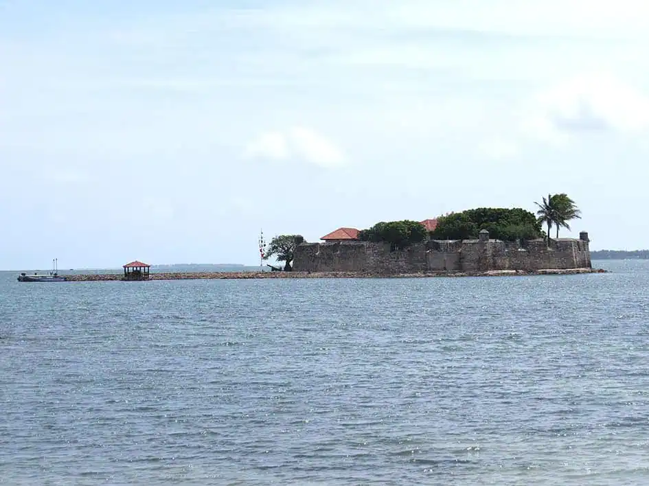
Fort Hammenhiel (Photo: Nalaka Priyantha)
Location
Fort Hammenhiel stands between the Jaffna mainland and Karaitivu Island, surrounded by water. The setting immediately sets it apart from many other forts in Sri Lanka, as the sea defines every direction around the structure.
Brief History
Portuguese authorities established the site, and Dutch authorities later expanded the fort according to changing military requirements. The location later served various functions, including as a prison and a military outpost.
Its position between islands created strong defensive advantages and controlled movement through surrounding waters.
Architecture
The island’s isolated location led to a compact defensive design, with limited space shaping planning decisions.
The structure reflects direct military thinking where efficiency and protection determined construction choices.
Special Features and Current Remains
The surrounding sea creates one of the strongest visual experiences among the forts in Sri Lanka. Visitors often remember the isolated atmosphere because the structure appears separated from the mainland world around it.
Much of the fort still preserves its historical character. It continues to reflect the strategic purpose for which it was originally built.
Today, visitors can stay at the fort, which now operates as a hotel.
Best Time to Visit
June through September generally provides suitable weather conditions.
Nearby Attractions
Travellers often combine Fort Hammenhiel with Jaffna islands, coastal viewpoints, cultural sites, and nearby northern attractions.
If you are visiting Sri Lanka for the first time, we recommend reading our complete travel guide for first-time visitors and the best Sri Lanka travel itineraries for your travel season.

Sunset and Kids – Galle Fort (Photo: Brett Davies, CC BY-NC-SA 2.0)
Final Thoughts
The forts in Sri Lanka reveal stories that stretch far beyond military history. They explain how trade shaped communities, how colonial powers changed cities, and how local traditions adapted across centuries of change. Travellers often arrive in Sri Lanka expecting beaches, nature & wildlife, and mountain scenery. Historical sites are often added to travel plans at the last minute. Yet these places create another route through the island by connecting coastlines, cultures, and generations through spaces that still stand today.
Map – Forts in Sri Lanka
Sources and References:
- Sri Lanka Tourism, Official tourism portal for destination information, regional attractions, travel planning resources, and tourism insights.
- Sri Lanka Tourism Development Authority (SLTDA), Official government authority responsible for tourism development, destination planning, industry information, and tourism policies in Sri Lanka.
- Department of Archaeology, Sri Lanka, Official source for archaeological preservation, historical monuments, heritage conservation, and archaeological information related to Sri Lanka’s historical sites and fortifications.
- UNESCO World Heritage Centre, Old Town of Galle and its Fortifications, Official UNESCO resource describing the heritage value, history, and international significance of Galle Fort.
- Department of National Museums, Sri Lanka, Source for museum collections and historical materials relating to Sri Lanka’s cultural and colonial heritage.
- Galle Heritage Foundation, Source for conservation initiatives, historical research, and preservation activities related to Galle Fort.
- ICOMOS Sri Lanka (International Council on Monuments and Sites), Reference source for heritage conservation and architectural documentation.
- National Archives of Sri Lanka, Historical records and documentation relating to colonial administration and heritage sites.
- Ministry of Buddhasasana, Religious and Cultural Affairs, Sri Lanka, Source for cultural preservation policies and heritage information.
- Central Cultural Fund, Sri Lanka, Government organization involved in conservation and heritage site management.
- Brohier, R. L. Ancient Irrigation Works in Ceylon. Government Press, Colombo.
- De Silva, K. M. A History of Sri Lanka. University of California Press.
- Paranavitana, Senarath. A Concise History of Ceylon.
- Pieris, Paulus Edward. Ceylon and the Portuguese, 1505–1658.
- Pieris, Paulus Edward. Ceylon and the Dutch, 1658–1796.
- Arasaratnam, S. Dutch Power in Ceylon, 1658–1687.
- Mills, Lennox A. Ceylon Under British Rule, 1795–1932.
Featured image (cropped): The Clock Tower – Galle Fort (Photo by Thilina Alagiyawanna, via Pexels)

I am a Sri Lankan medical doctor who spends my free time travelling, exploring new destinations, and documenting the beauty of the island I call home. I have journeyed across almost every corner of Sri Lanka with my wife and daughter — from wildlife parks and misty mountains to ancient cities, deep forests, rugged landscapes, and quiet beaches.
Travel is not just a hobby for me — it’s a way of life. I love nature, enjoy road trips, and find joy in wildlife photography. I also read widely about tourism, travel trends, and destination culture. Through my writing, I aim to help travellers experience Sri Lanka through real stories, meaningful insights, and honest recommendations — the same way I explore it with my own family.