


Discover Sri Lanka’s Dramatic Mountain Viewpoints
Early on a clear morning in Horton Plains National Park, a walking trail crosses open highland grassland and patches of stunted cloud forest. Then it stops at the edge of an escarpment, and the land falls away towards the southern lowlands far below. Come back a few hours later, and you may see nothing but drifting white cloud. That contrast between a huge view and a blank wall of mist is a good introduction to the World’s Ends in Sri Lanka.
Horton Plains made the name famous, but other viewpoints in the hill country have since taken it up, usually as “Mini World’s End”. This guide covers six of them. Two are inside Horton Plains, and most visitors see both on the same walk. The other four are separate trips: Pitawala Pathana near Riverston, Madulsima near Badulla, Deanston in the Knuckles range, and Selagama in Matale District.
The six are very different. One pair sits on a managed national park trail with ticket counters and a visitor centre. Others are reached by narrow rural roads and paths with little published information. Knowing which is which will help you pick the viewpoint that suits your route, your fitness, and the time you have.
Read about the 25 best viewpoints in Sri Lanka.
What Are the World’s Ends in Sri Lanka?
Why Are They Called World’s End?
Each of these places sits where high ground ends suddenly in a steep drop. When cloud fills the valley below, it can look as if the land stops. Sri Lankans often use the Sinhala word Lokanthaya, which carries the same meaning.
Are World’s End and Mini World’s End the Same?
Not quite. At Horton Plains, World’s End (often called Great World’s End) is the main, larger cliff. Mini World’s End is a smaller drop on the same trail. Elsewhere, “Mini World’s End” is a local nickname for viewpoints with a similar feel. These places have no official link to Horton Plains. Their names are informal, and you’ll see spellings vary, such as Pitawala Patana and Pitawala Pathana.
Where Are the Six Viewpoints?
- Great World’s End and Mini World’s End: Horton Plains National Park, south of Nuwara Eliya
- Pitawala Pathana: Riverston area, Matale District
- Madulsima (Pitamaruwa): Badulla District, Uva Province
- Deanston: Knuckles Mountain Range, near Hunnasgiriya
- Selagama: Matale District
This isn’t a complete list of every viewpoint in Sri Lanka that carries the name. It’s a practical selection, and each place has its own access and conditions.
1. Great World’s End – Horton Plains National Park

My daughter, Nethuli, is at Great World’s End (Photo: Nalaka Priyantha)
What Makes It Special?
Horton Plains National Park is a high, rolling plateau more than 2,000 metres above sea level. It’s a mix of tussock grassland, cloud forest, and streams, very different from the tropical image many visitors have of Sri Lanka. At its southern edge, the plateau ends at World’s End. The drop here is usually given as about 880 metres. That figure appears in guidebooks and tourism sources, though some quote slightly different numbers. On a clear morning, you look down over tea country and lowland hills that stretch far to the South.
The park is an important part of the Central Highlands of Sri Lanka, listed by UNESCO as a World Heritage Site in 2010. Sambar deer are often seen grazing on the open grassland.
Read about UNESCO World Heritage Sites in Sri Lanka.
Location and How to Get There
The park lies in Nuwara Eliya District, with two road entrances. Coming from Nuwara Eliya, you enter at Pattipola via Ambewela. From the Haputale, Bandarawela, or Ella side, you enter at Ohiya. After buying tickets at the entrance, you drive on to the visitor centre at Farr Inn. At this former colonial hunting lodge, the walk begins.
Most travellers come by private car or hired driver from Nuwara Eliya, about 30 km away. Allow at least an hour each way on narrow mountain roads. Trains stop at Pattipola and Ohiya, but both stations are around 10 km from the trailhead, so you’ll still need road transport for an early start.
Foreign visitors pay a park fee set in US dollars, plus vehicle charges and taxes. Fees change, so check current rates with the Department of Wildlife Conservation before you go. The park opens early (6 am is the commonly given time), and ticket counters stop issuing tickets in the afternoon.
Opening hours of Horton Plains National Park: Between 6:00 am and 6:00 pm daily.
You can book the entrance tickets online through the official Wildlife Park Permits Reservation eService.
Trail:
Hiking Experience and Difficulty
The main loop is roughly 9 km and takes most people three to four hours at an easy pace. It isn’t technical, but it isn’t a stroll either. Expect rocky, uneven sections, roots, and mud after rain. Most visitors walk it clockwise, reaching Mini World’s End first, then Great World’s End, then Baker’s Falls, before crossing the grassland back to the start. Toilets and a café are at the visitor centre only, not along the trail.
Best Time to Visit
Go as early as you can. Clouds often rise over the escarpment by mid-morning, so reaching the edge soon after opening gives you the best chance of a view. Drier months tend to be better, but weather here changes quickly, and nothing is guaranteed.
Nearby Attractions and Travel Tips
Baker’s Falls, a waterfall in a forested gorge, is part of the same loop. The park bans polythene and plastic, and staff may check bags at the entrance, so carry food in paper or reusable containers. Stay on marked paths and don’t feed or touch wildlife. Many travellers stay in Nuwara Eliya the night before. It’s colder up here than most people expect, especially at dawn.
2. Mini World’s End – Horton Plains National Park
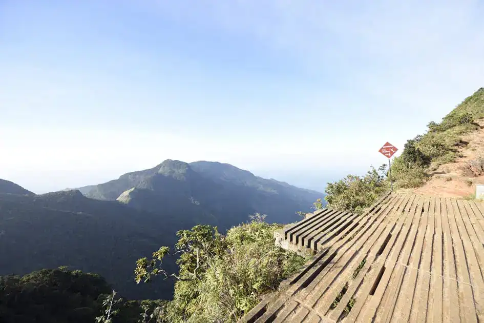
Mini World’s End – Horton Plains (Photo: Nalaka Priyantha)
Why Visit?
Mini World’s End is a smaller escarpment, with a drop most often given as about 270 metres. It looks out over the lower hills and valleys beyond the plateau. It’s less dramatic than the main cliff, but you reach it first on the usual clockwise route, earlier in the morning. That means it can still be clear when clouds are already building elsewhere.
Location and Access
Mini World’s End is inside Horton Plains National Park, on the same loop trail as Great World’s End. You don’t need a separate ticket or a separate trip. Treat the two viewpoints as one excursion: one early start, one park ticket, and one walk.
What to Expect on the Trail
From the visitor centre, the path crosses grassland, then drops into forest before coming out at the edge. On the usual route, Great World’s End is about a kilometre further on. The ground near the drop is uneven and can be slippery when mist settles on it.
Best Time and Practical Tips
The same rule applies: go early. Don’t spend so long at Mini World’s End that the main view clouds over before you get there. Stay well back from the edge, even if others are standing closer for photos, and keep a close eye on children.
3. Pitawala Pathana Mini World’s End – Riverston, Matale
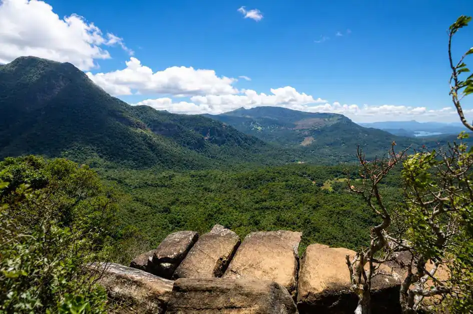
Pitawala Pathana Mini World’s End (Photo: Nalaka Priyantha)
What Makes It Special?
Pitawala Pathana is a small, open grassland on the northern part of the Knuckles Mountain Range. Its thin soil lies over a gently sloping rock slab, dotted with scattered shrubs and trees. At the far end, the grassland stops at a sheer drop known locally as Punchi Lokanthaya, or Mini World’s End. Central Province Tourism gives the drop as about 300 metres, though other sources quote slightly different figures. On a clear day, you look across forested valleys and the folds of the Knuckles range.
The grassland matters for conservation as well as scenery. It is home to Kirtisinghe’s rock frog, an endangered species found only in this area. That’s a good reason to stay on the path.
Location and How to Get There
The site lies beside the Matale–Illukkumbura road, about 34 km from Matale town. The route passes Rattota and climbs through a series of hairpin bends towards Riverston. Allow around 1.5 to 2 hours by car or tuk-tuk from Matale, and longer from Kandy.
Don’t confuse Pitawala Pathana with Riverston itself. Riverston is the wider area of high passes and peaks, while the Mini World’s End is a separate, signposted stop a short way down the road on the Illukkumbura side. A car park and ticket office are at the start of the trail.
Walking Trail and Difficulty
This is the easiest of the remote viewpoints. A nature trail of roughly 750 to 800 metres crosses the grassland to the edge, and most people do it in 15 to 20 minutes each way. The rock can be slippery when wet. Wind at the edge can be strong enough to unbalance an adult, so stay well back from the drop.
Best Time to Visit
Mornings usually give the clearest views before cloud builds. After rain, expect leeches in the grass, so tuck trousers into socks or use a repellent.
Nearby Attractions and Travel Tips
Pitawala Pathana fits well into a slow day exploring Riverston and the northern Knuckles. Food and facilities are limited out here, so bring water and snacks from Matale. Matale or Kandy work as bases, and a few simple guesthouses are closer to Riverston.
4. Madulsima Mini World’s End – Pitamaruwa, Badulla

Madulsima Mini World’s End (Photo: vined mind from Pixabay)
Why It Is Worth Exploring
Madulsima is the most remote of the six. The viewpoint sits on the eastern edge of the central highlands, beyond the Roeberry tea estate near Pitamaruwa. Its rocky edge drops by more than 300 metres, according to several local sources. It’s best known for the view over the clouds. On some mornings, low cloud fills the lowlands below and drifts up over the ridges just beneath the viewpoint.
Visit Uva describes it as a lesser-known place for foreign travellers but popular with Sri Lankan hikers and campers. You’re more likely to share it with local groups than with tour buses.
Location and How to Get There
Most visitors drive from Passara along the road to Madulsima village, then continue on narrow estate roads to Pitamaruwa. Expect around 1.5 hours or more from Badulla, and longer from Ella. Distances vary between sources, but the drive from Ella is over 75 km of winding hill roads. The last stretch includes a gravel road. A hired car with a driver who knows the area makes this much easier, and some travellers come by tuk-tuk.
Walking Experience and Accessibility
From the small car park on the estate road, a path of about 1.5 km leads to the rocky viewpoint. It’s walkable for most reasonably fit people, but it’s exposed. Wind can be strong at the edge, and the weather can change quickly. Before sunrise, it can be surprisingly cold.
This is not a managed attraction with barriers or staff on hand. So keep a safe distance from the drop and avoid walking near the edge in mist.
Best Time to Visit
Early morning gives the best chance of the cloud views the site is known for. Some local sources point to February and March for cloud formations, but conditions vary from day to day.
Nearby Attractions and Travel Tips
Madulsima also has waterfalls and other viewpoints, including the nearby Rathkele Pathana. Camping right at the Mini World’s End reportedly needs special permission, so book through an established campsite. There are few shops near the viewpoint. Bring water and food, and set off early enough to drive back to Badulla or Ella in daylight.
5. Deanston Mini World’s End – Knuckles Mountain Range
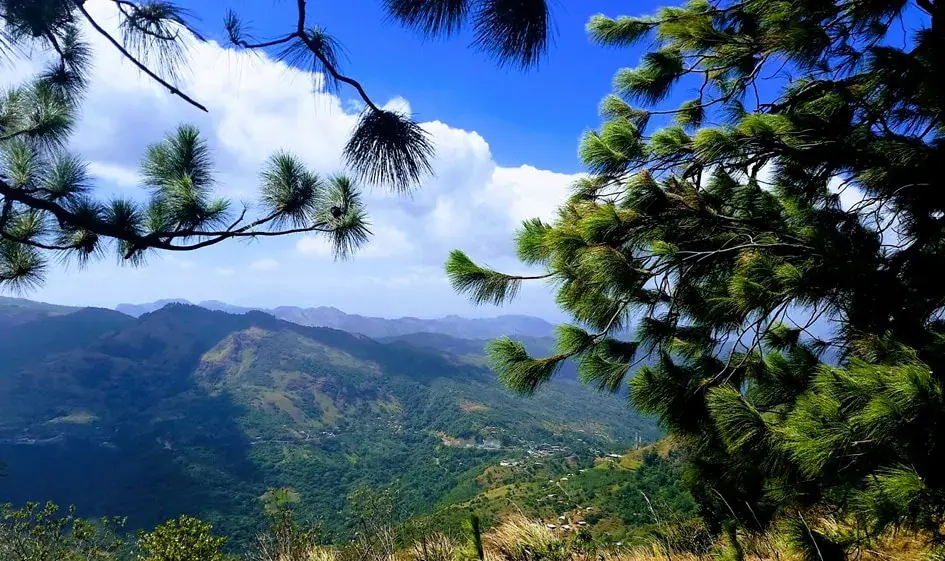
Deanston Mini World’s End (Photo: Ruwangiudawattage, CC BY-SA 4.0)
What Makes Deanston Special?
Deanston sits on the southern side of the Knuckles Conservation Forest, part of the same UNESCO-listed Central Highlands as Horton Plains. Its Mini World’s End is a cliff-top viewpoint overlooking valleys toward the Ududumbara area. It feels different from Pitawala Pathana. Here you walk through forest and pine plantation rather than across open grassland, and the setting feels more like part of a wider trekking region.
Location and How to Get There
From Kandy, take the A26 east towards Hunnasgiriya. From Hunnasgiriya, Deanston is about 7 km along the road towards Corbett’s Gap and Meemure. Expect a slow drive on a narrow mountain road in uneven condition. The walk begins at the Forest Department’s Knuckles Conservation Centre, also called the Knuckles Information Centre, at Deanston.
Hiking Trail and Difficulty
According to Central Province Tourism, this is a short, easy hike on a single path, with a round trip of about 3 km. One section crosses a fence by ladder. You won’t need specialist gear, but the ground can be muddy, and leeches are common in wet weather. Check at the conservation centre about entry tickets or guide requirements before you set off, as rules in the Knuckles reserve can change.
Best Time to Visit
As with the other viewpoints, mornings are usually clearer. The Knuckles range gets heavy rain in some months, and mist can close in fast, so allow extra time and be flexible.
Nearby Attractions and Travel Tips
Deanston is a natural stop on the way to Corbett’s Gap and the village of Meemure, both popular with trekkers. The Dothalugala nature trail also starts from Deanston. Kandy makes a practical base for a day trip, while staying near Meemure suits travellers who want several days in the Knuckles. Phone signal can be patchy in the mountains, so tell someone your plans if you walk without a guide.
6. Selagama/Hulangala Mini World’s End – Matale
Discovering a Lesser-Known Viewpoint
Locally, this viewpoint is usually called Hulangala Mini World’s End, after the rocky hill above it. It lies within the Selagama tea estate, on the hills between Matale and Kurunegala. The cliff top sits at about 760 metres, lower than the other viewpoints in this guide. The top of the cliff is in Matale District, while its base is already in Kurunegala District.
Because it’s lower, the view is different. Rather than looking over mountain valleys, you look out over the plains of Kurunegala and Matale, with the higher hills further away. Published information about this site is thinner than for the others, so treat the details below as a starting point and confirm them locally.
Location and How to Get There
The usual approach is via Yatawatta, on the B409 road that links Matale and Kurunegala. From there, a minor road climbs towards the Selagama estate. Sources put the viewpoint roughly 20 to 25 km from Matale town. It’s also reachable from Kurunegala, around 40 km away, via Thalgodapitiya. The estate charges a small entry fee, so carry some cash.
Walking Experience and What to Expect
From the estate entrance, the trail to the viewpoint is about 2 km. Local sources describe it as gently uphill rather than steep. Some motorbikes, tuk-tuks and four-wheel-drive vehicles go further up the track. Walking is the calmer option, and it’s kinder to the estate. Strong winds are common at the top. The local name is often translated as “wind rock”. The cliff edge has no railings, so keep children close and stay well back. From the viewpoint, a path continues to the summit of Hulangala itself for those wanting a longer walk.
Best Time to Visit
Mornings usually give clearer views before haze or cloud builds. There’s little reliable information on seasonal patterns specific to this site. Its lower height means it may clear earlier than higher viewpoints, but don’t rely on that.
Practical Considerations
Facilities near the viewpoint are limited, so bring water and snacks. Remember you’re on a working tea estate, where people live and work. Keep to the path, don’t pick tea, and ask before photographing workers or homes.
Comparing the Six World’s Ends: Which Should You Visit?
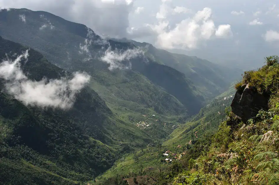
A View from the World’s End (Photo: Gwen Fran, CC BY-SA 2.0)
Each viewpoint suits a different kind of traveller. Horton Plains is the most organised option and the easiest to fit into a classic hill-country route. It also involves the longest walk. Pitawala Pathana gives the quickest reward for the least effort, while Madulsima demands the most travel. Deanston and Selagama suit travellers already spending time around Kandy or Matale.
| Viewpoint | Best for | Walk (approx.) | Access |
| Great World’s End (Horton Plains) | First-time visitors, hikers | 9 km loop, 3–4 hrs | National park with ticket counters and a visitor centre |
| Mini World’s End (Horton Plains) | Combined with the above | On the same loop | Same park ticket |
| Pitawala Pathana | Short walks, families | 750–800 m each way | Roadside car park, ticket office |
| Madulsima (Pitamaruwa) | Cloud views, adventurous travellers | About 1.5 km from car park | Remote estate roads, partly gravel |
| Deanston | Forest walks, Knuckles trekkers | About 3 km return | Slow mountain road from Hunnasgiriya |
| Selagama (Hulangala) | Quieter visits near Matale | About 2 km from estate entrance | Tea estate entrance, small fee |
Distances come from official and local tourism sources. They’re approximate and may vary depending on where you park and which path you take.
Best Time to Visit the World’s Ends in Sri Lanka
Understanding Mountain Weather
The six viewpoints sit in different parts of the highlands, and Sri Lanka’s two monsoons affect them differently. Horton Plains, in the southern hills, is wettest during the Southwest Monsoon, roughly May to September. The Knuckles range, home to Pitawala Pathana and Deanston, gets its heaviest rain on its northern and eastern slopes during the Northeast Monsoon, from about October or November to January. Madulsima, on the eastern edge of the hills in Uva, also gets Northeast Monsoon rain.
Best Months for Clear Views
For Horton Plains, the drier months from about January to March are generally the most reliable. The Knuckles viewpoints often improve from February onwards, once the Northeast Monsoon eases. At Madulsima, local sources suggest February and March for cloud formations below the viewpoint. These are tendencies, not promises. Mist can roll in on any day, in any month.
Why Early Morning Often Helps
At all six sites, clouds tend to build as the day warms and moist air rises up the slopes. Arriving early gives you the best chance of a clear view. Late mornings are often when visitors find nothing but white.
Rainy-Season Considerations
You can still visit in wetter months, but expect slippery rock, muddy paths, leeches, and a higher chance of seeing nothing. The transition months of October and November can bring afternoon storms across the hills. Build spare days into your plans, and check road conditions after heavy rain.
Read about the weather and the best time to visit Sri Lanka.
How to Plan a World’s End Adventure
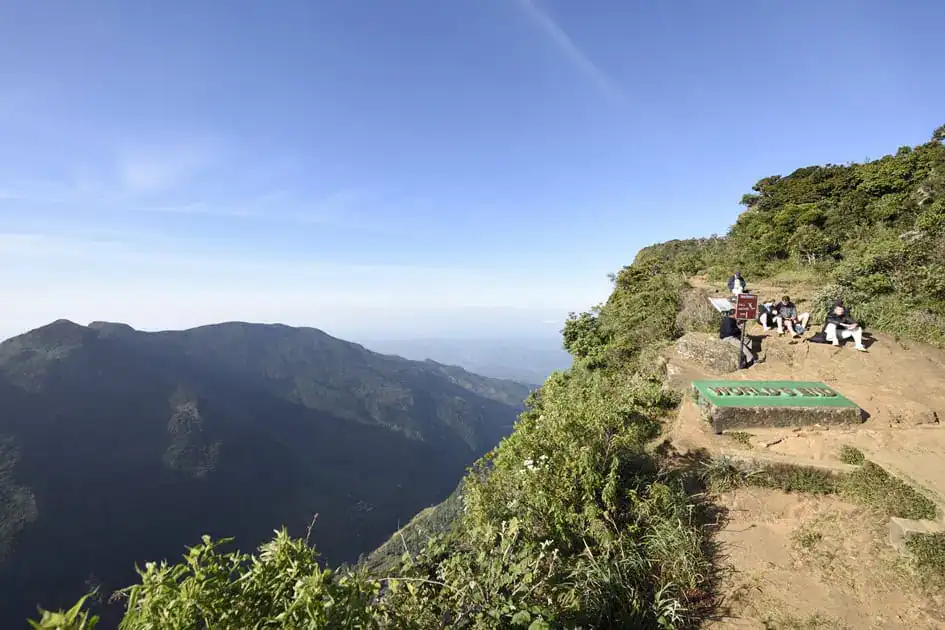
View from the Great World’s End (Photo: Nalaka Priyantha)
Which Viewpoints Can Be Combined?
Think of these as four separate trips:
- Horton Plains: both Great World’s End and Mini World’s End on one early-morning walk.
- Matale side: Pitawala Pathana and Selagama. They’re on opposite sides of the Matale valley, so it’s easiest to visit them on separate mornings from one base.
- Knuckles south: Deanston, which pairs naturally with Corbett’s Gap or a stay near Meemure.
- Uva: Madulsima, as a long day from Ella or Badulla, or with an overnight stay nearby.
Visiting all six means several days of slow mountain driving and very early starts. Most travellers enjoy two or three far more than all six in a rush.
Independent Travel or Guided Tours?
Horton Plains is straightforward with a hired driver. You can walk the main loop on your own, though you’ll need to buy park tickets. For Madulsima, Deanston, and Selagama, a driver who knows the local roads saves a lot of time. A local guide is worth considering if you plan longer walks in the Knuckles.
Where Should You Stay?
For Horton Plains, Nuwara Eliya is the usual base, while Ohiya and Haputale are closer to the southern entrance. Matale or Kandy work for Pitawala Pathana and Selagama, with simple stays closer to Riverston. Kandy or the Knuckles villages suit Deanston, and Ella or Badulla suit Madulsima. For ideas on fitting these into a wider route, see our things to do in Sri Lanka.
Essential Safety Tips
Most problems at these viewpoints come from the weather and the cliff edges, not the walking itself.
- Respect the edge. Most of these viewpoints have few or no railings, and some have none. Stay several metres back from the drop. Never sit on the edge or lean out for a photo, and keep children within arm’s reach. Fog can hide the edge completely, so slow down when visibility drops.
- Expect sudden changes. Wind, cloud, and rain can arrive within minutes, especially later in the morning. If conditions turn, head back rather than waiting at the edge for the view to clear.
- Watch your footing. Wet rock, roots, and grass are slippery. Stay on marked paths, which also protects fragile grassland and forest.
- Plan for patchy signal. Phone signal coverage can be unreliable in remote areas. Tell someone your plans, start early, and aim to be off the trail well before dark.
- Leave wildlife alone. At Horton Plains, sambar deer can be bold around people. Don’t feed them or any other animal. In wet weather, check yourself for leeches.
- Drones: Don’t fly a drone without proper permission. Protected areas have their own rules.
- Leave no trace. Carry out all rubbish, and respect the plastic ban at Horton Plains.
Read sustainable travel in Sri Lanka: How to explore responsibly.
What to Pack for a World’s End Hike

Pitawala Pathana Mini World’s End (Photo: Nalaka Priyantha)
Early mornings in the highlands can be cold, sometimes close to freezing at Horton Plains in the drier months. Bring a warm layer and a light waterproof jacket, even if the coast was hot the day before. Wear walking shoes or trainers with good grip rather than sandals.
Carry water, snacks, and sun protection, and keep a little cash for tickets and small fees. Leech socks or repellent are worth packing for the Knuckles and for any visit after rain.
For Horton Plains, use paper or reusable containers, as bags may be checked at the entrance. For the remote viewpoints, add a torch, a charged phone, and a power bank, and bring enough food and water to be self-sufficient. Shops are scarce near Madulsima in particular.
Frequently Asked Questions
How many World’s Ends are there in Sri Lanka?
There’s one main World’s End, at Horton Plains. Several other viewpoints are known locally as Mini World’s Ends. This guide covers six well-known viewpoints, but the name is informal, and other places may use it too.
Which is the most famous?
Great World’s End at Horton Plains National Park is by far the best known. It’s also the most visited and the best organised.
What is the difference between World’s End and Mini World’s End?
Great World’s End is the main, larger cliff at Horton Plains. Mini World’s End is a smaller drop on the same trail. Elsewhere, “Mini World’s End” is a local nickname for viewpoints with a similar sudden drop.
Which is best for beginners?
Pitawala Pathana has the shortest walk, under a kilometre each way across a grassland. Horton Plains also suits reasonably fit beginners, since the trail is clear but takes several hours.
Can you visit both Horton Plains viewpoints in one day?
Yes. Both are on the same loop trail and covered by one park ticket, and most visitors see them on the same morning.
Is hiking to World’s End difficult?
It’s moderate rather than difficult. The Horton Plains loop is long and uneven in places, but it isn’t technical. The shorter Mini World’s End walks elsewhere are easier, though some are exposed to wind.
Are these viewpoints safe for tourists?
They’re generally safe if you treat the cliff edges with respect, check the weather and keep to the paths. The risks are higher at remote sites with no barriers or staff, so take extra care at Madulsima and Selagama.
Do you need a guide?
You don’t need one for the main Horton Plains loop. For the remote viewpoints, a driver who knows the roads is very useful. Consider a local guide for longer walks in the Knuckles.
Can you visit in the rainy season?
Yes, but views are much less likely, and paths become slippery and leech-prone. The rainy months also differ by region, so check which monsoon affects the viewpoint you plan to visit.
Which is closest to Ella?
By road, Horton Plains is usually the closest, reached through the Ohiya entrance. Madulsima is also a day trip from Ella, but it’s a longer drive on winding roads.
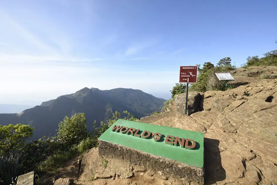
Edge of the Great World’s End (Photo: Nalaka Priyantha)
Are you new to Sri Lanka? Read about the best travel itineraries for your travel season and our ultimate travel guide for first-time travellers.
Final Thoughts
The World’s Ends in Sri Lanka aren’t a single attraction to tick off. They’re a group of very different viewpoints spread across the highlands. If you only have time for one, Horton Plains gives you Great World’s End and Mini World’s End in a single well-organised morning. If you’re based near Kandy or Matale, Pitawala Pathana, Deanston, and Selagama are good choices for travellers who’d rather avoid crowds. Madulsima is worth the long drive for those who are happy to travel further and start very early.
Whichever you choose, the same rules apply: go early, stay flexible, and give the edge plenty of room. Some mornings, you’ll get the full view. Others, you’ll get mist and a walk through cloud forest or tea country. Both are a genuine part of exploring Sri Lanka’s hill country. Pick the viewpoints that fit your route, and let the rest of the highlands fill the time in between.
Map – World’s Ends in Sri Lanka
Sources and References:
- Sri Lanka Tourism Development Authority (SLTDA). Tourism Research and Statistics. Official tourism statistics, visitor information, and tourism research relating to Sri Lanka’s attractions.
- Sri Lanka Tourism. Official Sri Lanka Tourism Website. Destination information, national parks, hill-country attractions, and travel-planning resources.
- UNESCO World Heritage Centre. Central Highlands of Sri Lanka. Official information about the UNESCO World Heritage property encompassing Horton Plains National Park, the Knuckles Conservation Forest, and the Peak Wilderness Protected Area.
- Department of Wildlife Conservation, Sri Lanka. Official Website. Information about national park conservation, wildlife protection, visitor regulations, and protected-area management.
- Central Province Tourism Department. Pitawala Pathana. Official destination information about Pitawala Pathana Mini World’s End, its location near Riverston, distinctive grassland ecosystem, and surrounding scenery.
- Central Province Tourism Department. Deanston Mini World’s End. Information about the Deanston viewpoint, its walking trail, and access through the Knuckles region.
- Central Province Tourism Department. Hiking and Trekking. Regional hiking opportunities, mountain landscapes, and attractions around Riverston and the Knuckles Mountain Range.
- Uva Province Tourism. Mini World’s End – Madulsima. Official regional tourism information about Madulsima’s Pitamaruwa Mini World’s End, its landscape, location, and surrounding tea estates.
- Elkaduwa Plantations Ltd. Hulangala Mini World’s End. Estate-operator information about Hulangala Mini World’s End at Selagama, including its location, access routes, and walking opportunities.
Featured image: Great World’s End – Horton Plains National Park (Photo: Nalaka Priyantha)

I am a Sri Lankan medical doctor who spends my free time travelling, exploring new destinations, and documenting the beauty of the island I call home. I have journeyed across almost every corner of Sri Lanka with my wife and daughter — from wildlife parks and misty mountains to ancient cities, deep forests, rugged landscapes, and quiet beaches.
Travel is not just a hobby for me — it’s a way of life. I love nature, enjoy road trips, and find joy in wildlife photography. I also read widely about tourism, travel trends, and destination culture. Through my writing, I aim to help travellers experience Sri Lanka through real stories, meaningful insights, and honest recommendations — the same way I explore it with my own family.
Such a brilliant breakdown of Sri Lanka’s viewpoints! I did the Horton Plains trek a while back and completely agree that the early wake-up call is non-negotiable. That mist rolls in incredibly fast, and if you aren’t at the cliff edge by 7 AM, you literally just stare into a white wall of fog. I also remember being shocked by how freezing cold it was at dawn—I definitely underestimated how chilly it gets up there before the sun comes out. Your tip about layering up and carrying a poncho is absolutely spot on. Mountain weather is always the boss. When I was doing some high-altitude trekking in the Himalayas, we had to deal with that exact same ‘four seasons in one day’ issue. You think you’re prepared for the cold, but the wind at high altitudes cuts right through you unless you have the right gear. Thanks for the detailed guide, I’ll definitely have to check out the lesser-known viewpoints like Deenston next time!
Thank you for sharing your experience! Horton Plains can be surprisingly cold in the early morning, and the mist can certainly change the views very quickly. Arriving early and dressing in layers can make a real difference, although visibility always depends on the weather.
It’s interesting to hear your comparison with trekking in the Himalayas. Mountain weather can be unpredictable wherever you travel!
I hope you’ll have the opportunity to explore Deanston and some of Sri Lanka’s lesser-known viewpoints on your next visit. Thanks again for reading and sharing your thoughts!